Martin Lewis and Karen Wigen in “The Myth of Continents: A Critique of Metageography” address important questions regarding the world’s geography and the way in which it shapes people’s understanding of the world. Despite being commonly accepted principles, geographic divisions of the world such as countries and continents can be incredibly misleading. Thus, these spatial concepts require a second degree of study and critical analysis. By analyzing these basic geographic concepts that were historically and economically imposed by society, the authors invite the reader to think critically about spatial frameworks that manipulate our way of seeing the world. According to them, since elementary school, students have been obliged to organize their knowledge about the world into separate regions: “West” vs. “East”, “North” vs. “South”, and “First World countries” vs “Third World countries”. However, many times, these spatial conceptions obscure much more than reveal about the reality of the world. Therefore, the authors urge the reader to ask why do we have these boundaries and, most importantly, should we have them?
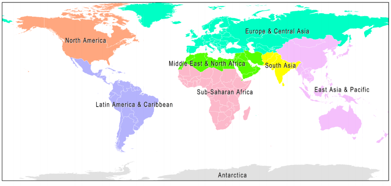
Lewis and Wigen divide Metageography into three different geographical concepts in order to start their analysis: “continents, nation-states, and supracontinental blocks, such as East and West.” Each of these concepts contains misconceptions and creates an incredibly misleading understanding of the world. However, the authors argue that the biggest problem with separating the world according to spatial relationships, such as sharply bounded units that fit together perfectly or to territorial hierarchies based on economic aspects, is that global geography tries to combine a huge dimension of different elements that shape the world. Each element, according to Lewis and Wigen, has its own distributional patterns. Thus, it is impossible to respond to a unique geographical phenomenon since it does not exist. However, the authors suggest that geographical concepts that are currently used should not be substituted for “an open-ended melange of overlapping and incommensurable distributional patterns.” Although the current set of geographical structures might be less than ideal, it is useful for people’s ability to talk about the world in an effective manner and hence facilitate conversation. As a result, Lewis and Wigen argue for a more general-purpose geographical framework. These are known as world regions and are based on important historical and cultural characteristics rather than physical separation per se. For instance, separations such as Latin America, South Asia, sub-Saharan Africa are regions in which landmass shapes are often ignored and would correct the eurocentric perspective which has prevailed until now.
According to the authors, like the other geographical schemes, “World Regions” are also not a perfect scheme to divide the world. Yet, given the real patterns in these regions, the authors suggest that they may be a better approach when attempting to improve understanding of global patterns geographically. However, the authors’ main intention by writing the book is not to convince the reader what is the best way to divide the world. Rather, they aim to expose historical, economic and political metageographical ideas that led to the global division we have currently. Their hope is that, by awakening broader interest in the subject, the reader himself will be able to decide, and perhaps develop, a more accurate geographical framework.